Genieße und Trage etwas bei!
| Finde die besten Spots |
|
|
 Angola
Afrika
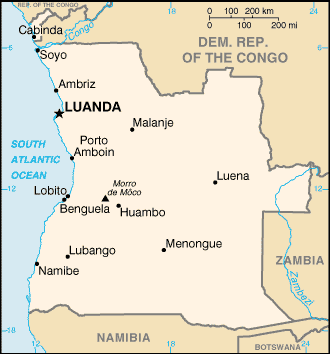
Ort: Southern Africa, bordering the South Atlantic Ocean, between Namibia and Democratic Republic of the Congo
Geografische Koordinaten: 12° 30' S, 18° 30' E
Küste km: 1,600 km km
Klima: semiarid in south and along coast to Luanda; north has cool, dry season (May to October) and hot, rainy season (November to April)
Gelände: narrow coastal plain rises abruptly to vast interior plateau
Höhe: lowest point: Atlantic Ocean 0 m
highest point: Morro de Moco 2,620 m
Natürliche Gefahren: locally heavy rainfall causes periodic flooding on the plateau
Währung: kwanza (AOA)
Bevölkerung: 12,127,071 (July 2006 est.)
Sprachen: Portuguese (official), Bantu and other African languages
Hauptstadt: Luanda
Bereiche: 18 provinces (provincias, singular - provincia); Bengo, Benguela, Bie, Cabinda, Cuando Cubango, Cuanza Norte, Cuanza Sul, Cunene, Huambo, Huila, Luanda, Lunda Norte, Lunda Sul, Malanje, Moxico, Namibe, Uige, Zaire
Mehr Details
| Jan | Feb | Mar | Apr | May | Jun | Jul | Aug | Sep | Oct | Nov | Dec | |
|---|---|---|---|---|---|---|---|---|---|---|---|---|
| Climate | ||||||||||||
| Air temp. | ||||||||||||
| Water temp. | ||||||||||||
| Wind consistancy | ||||||||||||
| Wind force | ||||||||||||
| Best season | 
|

|

|

|

|

|

|

|

|

|

|

|
Zusätzliche Karte

Möchtest du Informationen über Angola hinzufügen? Lass es uns wissen ...
Dies ist eine interaktive Karte! Verwende die Steuerelemente zum schwenken und zoomen.
- Kite Sessions (0)
- ausflüge (0)
- Fotos (4)
- Videos (0)
- Favorit
-
Deine Favouriten und Zukünftige-Spots-Listen
Spots
| Spots (2) | Qualität | Erfahrung | Typ | Einrichtungen | ||
|---|---|---|---|---|---|---|
| Buraco | - / - | Jeder | Lagune | |||
| Mussulo Lagoon | 4 / - | Fortgeschritten | 
|
 Kommentare
Errors, Feedback
Wenn du neue Information hinzufügen möchtest, oder Fehler in diesem Land gefunden hast, Schicken Sie uns Ihr Feedback.


