Passwort verloren? Neuer Benutzer? Registrieren
Genieße und Trage etwas bei!
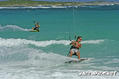
| Finde die besten Spots |
|
|
 Anguilla
Mittelamerika
Trade Wind. East in summer and North East in Winter.
Ort: Caribbean, islands between the Caribbean Sea and North Atlantic Ocean, east of Puerto Rico
Geografische Koordinaten: 18° 15' N, 63° 10' W
Küste km: 61 km km
Klima: tropical; moderated by northeast trade winds
Gelände: flat and low-lying island of coral and limestone
Höhe: lowest point: Caribbean Sea 0 m
highest point: Crocus Hill 65 m
Natürliche Gefahren: frequent hurricanes and other tropical storms (July to October)
Währung: East Caribbean dollar (XCD)
Bevölkerung: 13,677 (July 2007 est.)
Sprachen: English (official)
Hauptstadt: The Valley
Bereiche: none (overseas territory of the UK)
Mehr Details
| Jan | Feb | Mar | Apr | May | Jun | Jul | Aug | Sep | Oct | Nov | Dec | |
|---|---|---|---|---|---|---|---|---|---|---|---|---|
| Climate | ||||||||||||
| Air temp. | ||||||||||||
| Water temp. | ||||||||||||
| Wind consistancy | ||||||||||||
| Wind force | ||||||||||||
| Best season | ||||||||||||
Möchtest du Informationen über Anguilla hinzufügen? Lass es uns wissen ...
Dies ist eine interaktive Karte! Verwende die Steuerelemente zum schwenken und zoomen.
- Kite Sessions (0)
- ausflüge (0)
- Fotos (1)
- Videos (0)
- Teile
- Favorit
-
Deine Favouriten und Zukünftige-Spots-Listen
Spots
 Kommentare
Errors, Feedback
Wenn du neue Information hinzufügen möchtest, oder Fehler in diesem Land gefunden hast, Schicken Sie uns Ihr Feedback.
Von thierry dehove , 13-12-2008
- Anguilla has 30 beaches and amazing kitesurfing spots. I ridded most of the time between Cove Bay and Savannah with East wind.. somtimes in Meads Bay and Long bay with North wind.