Passwort verloren? Neuer Benutzer? Registrieren
Genieße und Trage etwas bei!
| Finde die besten Spots |
|
|
 Martinique
Mittelamerika
Ort: Caribbean, island between the Caribbean Sea and North Atlantic Ocean, north of Trinidad and Tobago
Geografische Koordinaten: 14° 24' N, 61° 0' W
Küste km: 350 km km
Klima: tropical; moderated by trade winds; rainy season (June to October); vulnerable to devastating cyclones (hurricanes) every eight years on average; average temperature 17.3 degrees C; humid
Gelände: the island is dominated by Mount Pelee, which on 8 May 1902 erupted and completely destroyed the city of Saint Pierre, killing 30,000 inhabitants
Höhe: highest point: Montagne Pelee 1,397 m
Natürliche Gefahren: hurricanes, flooding, and volcanic activity (an average of one major natural disaster every five years)
Währung: euro (EUR)
Bevölkerung: 429,510 (July 2004 est.)
Sprachen: French, Creole patois
Hauptstadt: Fort-de-France
Bereiche: none (overseas department of France)
Möchtest du Informationen über Martinique hinzufügen? Lass es uns wissen ...
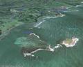
Dies ist eine interaktive Karte! Verwende die Steuerelemente zum schwenken und zoomen.
- Kite Sessions (0)
- ausflüge (0)
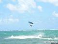
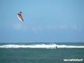
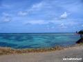
- Fotos (9)
- Videos (0)
- Teile
- Favorit
-
Deine Favouriten und Zukünftige-Spots-Listen
Spots
| Spots (2) | Qualität | Erfahrung | Typ | Einrichtungen | ||
|---|---|---|---|---|---|---|
| Luciole | 4 / - | Bekannt | Lagune | |||
| Pointe Faula | 5 / - | Jeder | Lagune | 


|
 Kommentare
Errors, Feedback
Wenn du neue Information hinzufügen möchtest, oder Fehler in diesem Land gefunden hast, Schicken Sie uns Ihr Feedback.