Passwort verloren? Neuer Benutzer? Registrieren
Genieße und Trage etwas bei!
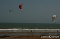
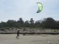
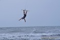
| Finde die besten Spots |
|
|
 Panama
Mittelamerika
Ort: Central America, bordering both the Caribbean Sea and the North Pacific Ocean, between Colombia and Costa Rica
Geografische Koordinaten: 9° 0' N, 80° 0' W
Küste km: 2,490 km km
Klima: tropical maritime; hot, humid, cloudy; prolonged rainy season (May to January), short dry season (January to May)
Gelände: interior mostly steep, rugged mountains and dissected, upland plains; coastal areas largely plains and rolling hills
Höhe: lowest point: Pacific Ocean 0 m
highest point: Volcan de Chiriqui 3,475 m
Natürliche Gefahren: occasional severe storms and forest fires in the Darien area
Währung: balboa (PAB); US dollar (USD)
Bevölkerung: 3,191,319 (July 2006 est.)
Sprachen: Spanish (official), English 14%; note - many Panamanians bilingual
Hauptstadt: Panama
Bereiche: 9 provinces and 1 territory*: Bocas del Toro, Chiriqui, Cocle, Colon, Darien, Herrera, Los Santos, Panama, San Blas*(Kuna Yala), and Veraguas
Möchtest du Informationen über Panama hinzufügen? Lass es uns wissen ...
Dies ist eine interaktive Karte! Verwende die Steuerelemente zum schwenken und zoomen.
- Kite Sessions (0)
- ausflüge (0)
- Fotos (7)
- Videos (0)
- Teile
- Favorit
-
Deine Favouriten und Zukünftige-Spots-Listen
Spots
| Spots (3) | Qualität | Erfahrung | Typ | Einrichtungen | ||
|---|---|---|---|---|---|---|
| Pedasi | 7 / - | Jeder | Offener Ozean | 


|
||
| Punta Chame | - / - | Jeder | Strand |
|
||
| Puntachame | - / - | Jeder | Offener Ozean |
|
 Kommentare
Sei der erste der einen Kommentar über dieses Land schreibt
Errors, Feedback
Wenn du neue Information hinzufügen möchtest, oder Fehler in diesem Land gefunden hast, Schicken Sie uns Ihr Feedback.